Tuesday, July 27, 2010
Home !
4:00 pm, Tuesday, July 27th arrived home
4 days earlier than expected - but what the heck.
So here are the final statistics:
487.9 miles on the road today.
14,393 total miles since June 20th
36 days on the road - not counting two days in Sugar Grove, PA
15 states
6 Canadian Provinces & Territories
4 New Tires
3 Oil changes
2 new hitchhiker friends
1 Heck of a trip!
From my driveway - furthest point south and east at 37.32 N, 77.40 W
Furthest point north - BP Security Gate, Deadhorse AK, 70.13 N
Furthest point west - Homer Spit AK, 151.31 W
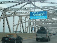
So, two more pics. See the Subaru returning to Virginia and don't it just fit?
One if the first vehicles I see in Virginia is a pickup truck hauling a Corn Dog and Funnel Cake Trailer. - Yee Haw - them Alaska rednecks got nuthin on us!
Hope you all have enjoyed the blog. And a public thanks to Dorene for her support of my little adventure.
Monday, July 26, 2010
July 26, 2010 - The mad dash home
Here we are in Lexington Kentucky - another university town, home of the University of Kentucky Wildcats.
It is 91 Degrees outside at 8:30 pm when we just got back from eating 2 McDonalds fish sandwiches. I am out of Ramen, but I suppose I could have had some beans or ravioli instead.
However, it is not good camping weather with a -15 F rated sleeping bag. Even though I'm not sure it would be comfortable at -15 F, I guarantee you it would not be comfortable at 91.
By the way, did you know that dogs will eat fish? Not nearly as good as fresh caught Alaskan halibut - but they are not picky.
So, anyway. This post is more for the record than entertainment. 574.9 miles today. From Iowa, through Illinois and Indiana, past Louisville - always a favorite place - and halfway through Kentucky on I-64. I will submit one more post tomorrow with the total mileage. So far, from when I left the Midlothian Kroger on June 20, 2010, it has been 13,906 miles - about 4,000 more than I originally estimated but I think that is just because I elected to wander around Alaska a little more than I intended. Same with several of the roads in Canada, Route 99 in particular.
GPS says it is 481.6 miles home from this hotel room - piece of cake!
38.03 N, 94.25 W
Sunday, July 25, 2010
Home of the Hawkeyes
So here I am at the Days Inn at the corner of Second Avenue (Route 6) and Hayden Fry Freeway in Coralvill IA, home of the Iowa Hawkeyes who, as I have been reminded, not only beat Penn State the last two years but have also beat Penn State in something like the last 8 of 9 matches.
That being said, I I stopped at a local bar and ordered another one of those teriffic fried pork tenderloin sandwiches along with a couple of bottles of good German beer and wondered why if Virginia is supposedly such a big pork producing state, why can't we figure out how to do a fried pork tenderloin sandwich?
I think I see an opportunity here. Occasionally a good idea will come from someplace other than Richmond - maybe even Iowa.
So, anyway, 543 miles today. Thought I'd try to take some of the Jack Kerouac Blue Highways home but soon found out that - other than Route 2 which is basically a 2 lane interstate, that the blue highways like US 81 do not have roadside rests to pull off and let your dog go pee. And despite the fact that the farms out here are hundreds if not thousands of acres of hay, cattle, soybean or corn, that pulling over to the side of the road onto someone's property is not a cool thing to do these days.
So, anyway, that put us back on to the interstates with the trucks, RVs and miscellaneous travelling trash like me.
Some pics from Hwy 81 around Lake Poinsett, north of Madison SD, showing some of the high water from the recent rains. Understand they've had some problems along the Missouri River and from what little I could see at Sioux City, the river was high and fast.
So, anyway, a toast to the Hawkeyes, they know how to eat. 41.40 N, 91.34 W. tomorrow Louisville, then Richmond by Tuesday evening.
Katie, Happy Birthday tomorrow. No longer a Teen Angel
On the way Home - in South Dakota
Not a real exciting day. Passed the “Geographic Center of North America” today in Rugby ND. 99.59.685 West. See pic of monument. Visitors lined up just like Denali and Glacier.
On in to South Dakota where cowboys are king – and big. Staying at a nice small park outside of Watertown SD. Sandy Point. Might get a night w/o rain. Place is the most sulphur smelling place since J&L Steel
469.8 miles today, 44.54 N. , 97.15 W. At least 3 more nights on the road.
Saturday, July 24, 2010
OOPS - Houston, we have a problem!
Road weary – stuff is breaking – too much wind and rain – time to come home See pic of Willow Lake by moonlight – so pretty, peaceful and calm. Well, not at midnight. I was asleep and here come this fierce and sudden wind and rain. Well, I got lazy last night and I did not close tha carrier all the way. Wind picked it up and slammed the top of the clamshell against the hood of the car. We now have some souvenir dimples. Also tore the front of the top clamshell by the hinge. The tarp went flying in the wind too. So there I was – old fat guy running around in the wind and the rain in my skivvies trying to do damage control. Well, got the clam shut and locked down. Threw the tarp onto the front seat of the car, shut the back hatch and Leo and I listened to the wind buffet the car until dawn. Fortunately, about 6:00 am, we got a break in the rain and we broke camp and got out of there. A stop at the WalMart in Havre Mt for some outdoor duct tape made us waterproof again . It will get us back to VA. Stopped at the Bowdoin Game preserve and toured – hoped to see buffalo or elk – not – but did see some big deer and one very large snake with cream colored belly and sides and black diamond shapes on its back. Could not swear it was a rattler – but that would be my guess. It was too fast for the camera. Wanted to stop at Williston ND but all campgrounds and hotels are full due to the ND State Fair in Williston this week. Oh well, it was raining anyway. By the way, ND now makes it all 48 of the lower 48 for me – plus of course Alaska. 1 more to go. So, pushed on to Minot and was lucky to find this small private campground. Actually very nice and reasonable – no amenities though – like running water. So, hope the pending rain is not as bad as last nights. Lots of new oil wells in the area Schlumberger and Halliburton crews all over the place. That’s part of the motel problem. (see pic of well) I’m also fascinated by these plains trains. Burlinton Northern Santa Fe – one was nine tenths of a mile long. Anyway, between weather and inability to count on accommodations, I’ve been getting a little discouraged. I find myself spending more time looking for places to stay rather than I do looking at places I want to look at. Besides, it’s been a month. So, tomorrow Minnesota and rocket east. 529 miles today, 48.17 N, 101.26 W
Out of the Mountains onto the Prairie
Started the day in Sandpoint ID at the Days Inn. Leo enjoyed his stay. I plotted out a general vicinity for a campground that I could reach by 5;30 or so, so off we go. First we passed the little known Moyie River Canyon and Dam – also a small (by Coulee standards) but not insignificant hydroelectric plant. Bridge over the canyon was over 400 ft.
Then iInto Montana. First into Kalispell where my brother Stu and I visited 32 years ago just about this time when I got out of he Army. It was a charming town then. It is still charming if you like small casinos and convenience stores for people in RVs headed to Glacier Park. Not so charming anymore. Passed Glacier Park – again – like Denali. Lots of RVs, lots of tourists. I skipped the park. But, got some great pics of white water rafting in the area on the Kootenai River – starts in Canada, flows into the Columbia.
Then through Blackfoot Country. Casinos – but cigarettes are $54.00 a carton or more (for Marlboro and Newport) Shortly after Cut Bank, it goes from mountains to prairie in about 30 miles – just amazes me the transition. Also amazed by the prairie trains. See Amtrak coming.
In one of the weat fields – just standing, I saw big buck Elk – huge rack. From a distance, I first though it was a piece of farm machinery – maybe an irrigation point or something . Then when I got up on him, it was too late for the camera. Oh well.
So finally made it to Willow Lake Campground – see if you can find the Willows – I can’t. Big lake. No one here and Leo has had a lot of room to play and swim. Now he’s listening to coyotes in the distance. Ought to make for a fun night.
369.1 miles today, 48.24 N, 111.15 W
Battery Low - more Pics Later
Wednesday, July 21, 2010
Across Washington into Idaho - what a change!
Woke up this morning among big Cedars and Redwoods, drove through a desert and now coming back into mountain Lodgepole Pine.
Coming into Leavenworth WA, there were some beautiful streams (rivers) I think the pics of the rapids are the Icicle River. Then come in to Leavenworth which is a replica of a Bavarian Village – it is beautiful and charming. Evn the commercial establishments – the Bank of America, the McDonalds, etc have to be done in Bavarian architecture. Again, very obviously charming and touristy.
Then coming out of Leavenworth in just a few short miles, the place turns into a desert. I had heard that Eastern Washington was very arid, but I had not expected the real desert look to it. There is a lott of irrigation – from the two great lakes that are part of the Columbia River – Banks and Roosevelt – and from those two, there is enough water for major fruit production. Miles of Washington Apple trees and grapes too.
Then on to Grand Coulee dam. Some pics of Lake Banks. Weird seeing such a huge body of fresh water in the middle of such an arid landscape. Then the dam itself is huge. 500 ft tall. It was started as a smaller dam in 1933 and then was expanded to generate electric power for Hanford to purify Plutonium. It was eventually completed in 1950 and is one of 14 dams on the Columbia River. Wow – Jeopardy, here I come!
By the way, had to add the picture of the road sign. I guess that was for the benefit of the blind drivers who could not see the rocks.
So, anyway, on to Spokane and I had a little time to spare, so I decided to get my third and hopefully last oil change on the road. Well, took a couple of hours and some waiting in traffic – in Spokane? C’mon! So, by the time I got to campsite #1 – it was full. On to alternate – it was full too – what are all these people doing? Did they all retire from Philip Morris at the same time?
So, anyway, I’m here in Sandpoint Idaho in a pet-friendly Days Inn. 364.1 Miles today, 48.18 N, 166.33 w
Plan to stay on Route 2 but will start looking for a campsite by about 3:00 pm. Will be in mountain Time in Montana. I figure 4 more days to home.
Sun Wolf was great – loitered a little bit this am – enjoyed having a real bed and a real shower. So – on the way to Vancouver and the US. Vancouver sneaks up on you really fast from Squamish. By the way - take a look at the picture of the road sign. Most of the road signs for places - villages, stream crossings, etc are in English and Squamish.
Basically, it turns in to the northern suburbs – very pretty by the way and this is definitely not the poor end of town. I thing all the rich Vancouverites live on this end of town so they can go play at Whistler skiing in the winter.
Getting in to Vancouver from this approach is has some great views of the Straits of Georgia . Saw the Ferry going over to Vancouver Island – but on the Highway and no place to pull off and get a shot. Caught a quick shot of some freighters coming in.
By the way, All of the road atlases warn of highway 99 from Whistler to Vancouver in the winter. Guess what – this is not the one lane road section that I was on yesterday. This is four lanes- beautiful new asphalt and maintained to a tee. I suspect in preparation for the Winter Olympics.
So anyway, Vancouver is a nice big clean city with a population of almost 3 million – from my friend Darren at Sunwolf last night. The south part of the city is more industrial / commercial and loaded with Chinese, Vietnamese, Cambodian, etc. Still very neat & clean from what I saw.
The south side of Vancouver ,Langley & White Rock are basically farming areas in tidal flats. At one point the altimeter on my GPS read -2 feet above sea level. Quite a change from 6300 ft two days ago.
Then waited in lin over an hour to cross into US. The checked me out good – took my passport card inside and ran a check on me since I was carrying a shotgun. I did not make any wisecracks about my strong Arabic accent. Anyway, the let me in.
Well, my intent was to go to Seattle. Well, I got down to the I-5, I -405 split and everything turned into 8 lane gridlock. So, I got off at the Lynwood exit to figure out where I wanted to go – well the answer was I did not want to see miles of traffic that badly – so I meandered back to Route 2 and headed east into the hinterlands. Much happier. Found a great little campsite at Alpine Falls in the Mt. Baker – Snoqualmie National Forest. Leo actually got to run off the leash tonite. Got lazy and heated up a can of Chef Boyardi ravioli on the hot car engine while I set up camp. Tomorrow, Grand Coulee Dam. Only 255.6 miles today, 47.44 N, 121.25 W
Subscribe to:
Posts (Atom)